Indonesia’s Forest Cover Status in 2025

Indonesia is one of the world’s mega biodiversity hotspots, with tropical forests that serve as habitats for thousands of endemic species and as vital ecosystem buffers. In addition to maintaining ecosystem balance, Indonesia’s forests also play a role in climate change mitigation through carbon sequestration and storage. However, these functions continue to face pressure due to deforestation, forest degradation, and land-use conversion. Forest management in Indonesia still faces various challenges, ranging from weak governance, inconsistencies in spatial planning, unclear tenure rights, to low law enforcement capacity.

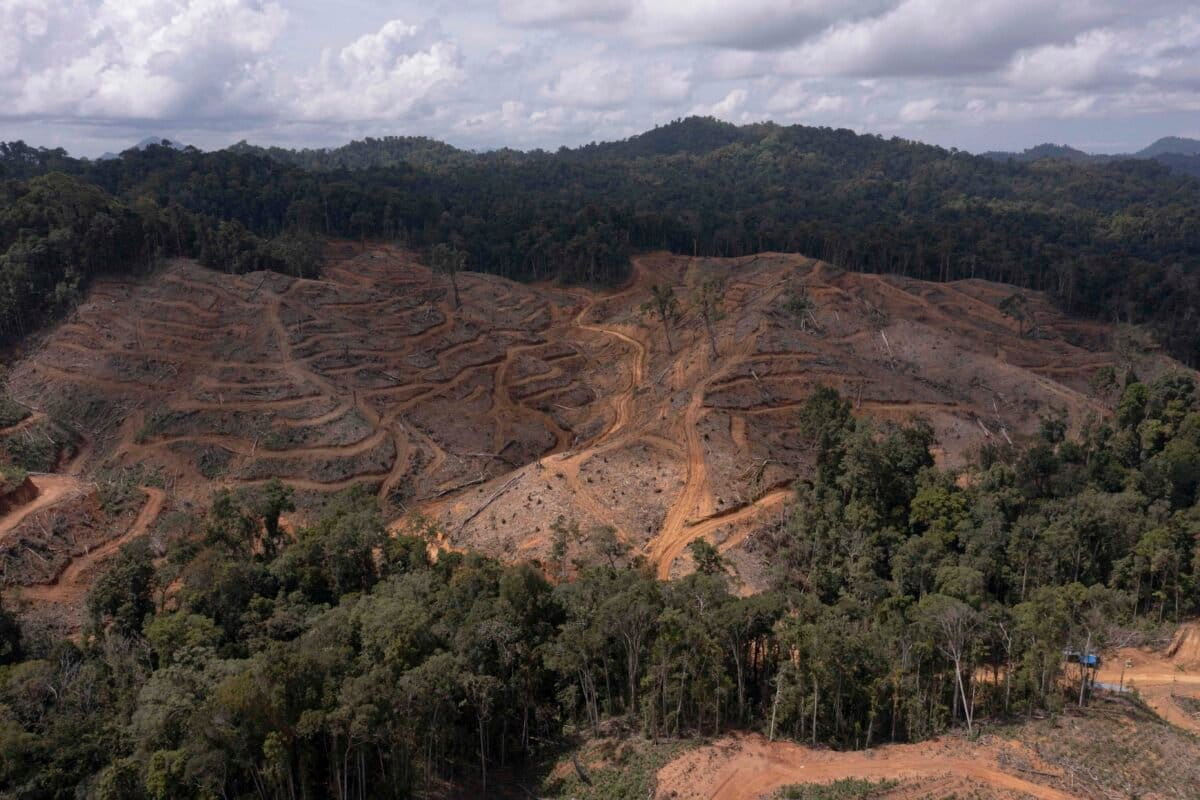
In 2022, the Ministry of Environment and Forestry (Kementerian Lingkungan Hidup dan Kehutanan/KLHK) released the Indonesia Forestry and Other Land Use (FOLU) Net Sink 2030 Operational Plan, a strategic policy instrument that sets a target for the forestry sector to achieve a net carbon sink status in support of the net-zero emissions target by 2060. Meanwhile, in 2024, the Ministry of Forestry also allocated an area of 20 million hectares for the expansion of food and energy reserves. This large-scale land allocation, accelerated by measures to streamline investment permitting, raises the likelihood of significant conversion of natural forest cover. The overlap between these policies demonstrates the government’s lack of seriousness in curbing deforestation rates and meeting its emissions targets.

To address these challenges, forestry data is crucial for supporting monitoring, policy evaluation, and improved governance. However, public access to forestry data remains limited, including information on the permitting system, concession maps, and the status of forest areas. Yet, open access to information is a prerequisite for strengthening transparency, accountability, and public participation in forest management.

Although information transparency is regulated under Law No. 14 of 2008 on Public Information Transparency, its implementation in the forestry sector remains suboptimal. This situation is exacerbated by economic pressures from various sectors, particularly the palm oil sector, which often expands at the expense of good governance principles. Therefore, open access to forestry data is a critical prerequisite for supporting public oversight, policy evaluation, and more sustainable forest management.

Considering this, Forest Watch Indonesia (FWI) has taken the initiative to promote transparency in forestry by producing and managing forestry data that is accessible to the public. This fact sheet presents up-to-date information on the dynamics of natural forests to serve as a basis for policy advocacy and efforts to promote more transparent and sustainable forest management.

The State of Forest Cover and Deforestation in Indonesia from 2024 to 2025

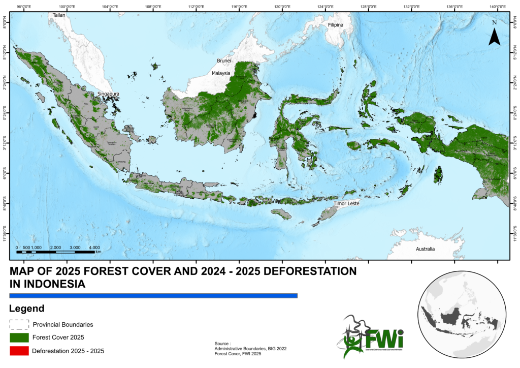
The State of Forest Cover and Deforestation in Indonesia from 2024 to 2025 The results of this study indicate that Indonesia’s remaining natural forest area in 2025 will be 88.43 million hectares, or 47% of the total land area. This area has decreased by 1.06 million hectares compared to 2024, when the natural forest area was 89.5 million hectares. This figure was derived from the output of the Random Forest model, which has proven highly effective in predicting Indonesia’s forest cover, with an Overall Accuracy of 0.984 ± 0.003 and a Kappa Coefficient of 0.967 ± 0.003.

Map of 2025 Forest Cover and 2024–2025 Deforestation in Indonesia

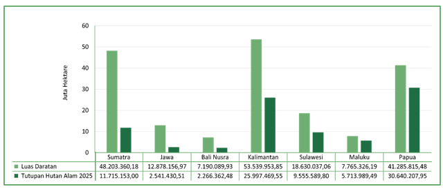
Indonesia’s natural forests are spread across seven regions representing the country’s major islands, namely Papua, Kalimantan, Sumatra, Sulawesi, Maluku, Java, and Bali-Nusa Tenggara. 64% of Indonesia’s remaining natural forests are located in the Papua Region (30.64 million hectares) and Kalimantan (25.99 million hectares). However, when viewed in terms of the FCR (Forest Cover Ratio), the proportion of remaining natural forest cover to total land area, the regions with the highest FCR values are in eastern Indonesia, namely Papua and Maluku, both with an FCR of 74%. Java and Sumatra are the regions with the lowest FCR values, at 24% and 20%, respectively.

Percentage of Forest Cover in 2025 Relative to Land Area

In addition to analyzing Indonesia’s remaining natural forests, this study also examines whether these remaining forests still possess good ecosystem functions. This is assessed by examining the level of fragmentation of the identified natural forests. Technically, in spatial and landscape ecology analysis, the level of forest fragmentation is a quantitative measure that describes the extent to which an intact forest block, such as an Intact Forest Landscape with a patch area of more than fifty thousand hectares (Potapov et al. 2025), has been broken up into smaller, isolated patches (fragments) due to non-forest land cover (Ritters et al. 2002).

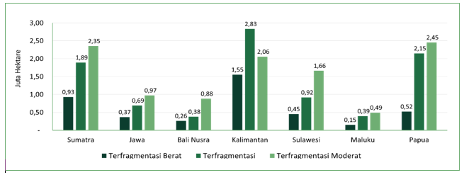
Perbandingan Luas Fragmentasi dan Fragmentasi Moderat Hutan Indonesia
Comparison of Extensive Fragmentation and Moderate Fragmentation in Indonesian Forests

Of the total 88.43 million hectares of identified natural forest, 3.9% or 3.4 million hectares are heavily fragmented natural forests, 9.6% (8.47 million hectares) fall into the fragmented category, 7% (6,2 million hectares) fall into the moderately fragmented category, and the remaining 80% (70.3 million hectares) still constitute intact natural forest landscapes. The Kalimantan and Sumatra regions have the largest areas of heavily fragmented natural forests, at 1.29 million hectares and 703.12 thousand hectares, respectively. Papua has the largest area of intact natural forest, at 26.51 illion hectares, representing more than 30% of its remaining natural forest by 2025. On the other hand, 1.68 million hectares of Papua’s natural forests have begun to experience fragmentation, albeit at a moderate level; this indicates that a significant amount of forest clearing activity has already begun, leading to a reduction in the area of intact forest landscapes in this last bastion of Indonesia’s forests.

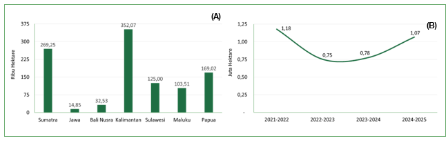
Deforestation in 2024–2025 by Region (A) and Indonesia’s Deforestation Trends, 2021–2025 (B)

Forest fragmentation and habitat loss are closely linked to rising deforestation rates in a region (Samsuri et al. 2021). Kalimantan is the region with the highest deforestation rate for the 2024–2025 period, at 352.06 thousand hectares, followed by Sumatra (269.25 thousand hectares) and Papua (169.02 thousand hectares).

In terms of trends, deforestation in 2024–2025 saw a significant increase compared to the previous year, amounting to 37%. Nearly all regions experienced an increase in deforestation, and Kalimantan once again recorded the largest increase, with total deforestation rising from 227.49 thousand hectares in 2023–2024 to 352.06 thousand hectares in 2024–2025. The Java and Bali-Nusra regions were the only two to experience a decline in deforestation, a trend closely linked to the fact that these regions have very little natural forest remaining.

The complete fact sheet publication can be downloaded at the link below:

Indonesia’s Forest Cover Status in 2025
Published: October 2, 2026

Thank you for your vote!
Post rating: 0 from 5 (according 0 votes)

Add Comment

Get the latest news via email

Good Forest Governance Needs Good Forest Information.


Using and sharing site content | RSS / Web Feeds

Photos and graphics © FWI or used with permission. Text available under a Creative Commons licence.

© Copyright 2020 FWI.
All Rights Reserved.

to top