Information Asymmetry: What Has Been Hidden from the Public on Indonesia Capital Relocation?

Information asymmetry remains as a fundamental problem in the management of natural resources in Indonesia. Matters on capital (ibu kota negara, IKN) relocation to newly named city of Nusantara, East Kalimantan is no exception. Public should be able to check and balance the policy-making processes that accompany the relocation of IKN to Nusantara. Not all  relevant matters of public interests have been well-presented in mainstream media, such as details on city ​​development plans, forest and land use policies, the fate of biodiversity, disasters risk mitigation, and the budget policies.


Public Information Disclosure is a mandate of the Public Information Disclosure Act. Every public agency is obliged to make information on public interest publicly available, particularly on matters concerning the life and safety of the people. In the context of IKN relocation, transparency should be the initial foundation, before building any physical infrastructures. In this regard, FWI seeks to break the asymmetric chain of information by providing complete and free-access information, relevant to the relocation of IKN to Nusantara, particularly on natural resource management-related details.

What is the Fate of Animals of the Remaining Natural Forest in the new IKN?

The new IKN is planned to be located in two regencies, namely Penajam Paser Utara and Kutai Kartanegara. The remaining forest in IKN Nusantara area is currently 26.8 thousand hectares, or only about 10% of the total area of ​​the Archipelago’s IKN area. Most of these forests are located in the Production Forest of ​​16.8 thousand hectares and in Other Use Areas of 8.5 thousand hectares. Meanwhile, only mere 5 hectares remained in the protected forest area.

FIGURE 1. NATURAL FOREST COVER WITHIN THE FUNCTION OF FOREST AREA IN IKN NUSANTARA
TABLE 1. FOREST AREA

The forest area is divided into several functions or uses. In IKN area, most of the natural forest cover is in the production forest area. The function of forest areas in Production Forests can be burdened by permits for forestry industry and other extractive industries. Particularly with current business licensing scheme, where licensing is facilitated through Online Single Submission (OSS) and multi-business licensing schemes, further deforestation will be very likely the case. This is an irony when IKN was said to apply Forest City concept, where 75% of the area should be covered by natural forest, hence 165 thousand hectares of reforestation should have been underway instead. Certainty has yet to be made regarding the protection status of the remaining natural forests in Nusantara. There has yet been a sight of shifting function/land use to forest area in Nusantara, potraying the lack of commitment in protecting natural forest. More details are discussed below.

Deforestation around Nusantara area from 2018 to 2021 has reached 18 thousand hectares, which is an alarming rate of loss in just 3 years.  Moreover, deforestation continued, even after IKN relocation to East Kalimantan was announced in 2019.

Most deforestation occurred in the production forest area which covered 50% of the remaining  natural forest as of 2018 and where most of the forest area in Nusantara area is located. The area has already been burdened by concession permits.

TABLE 2. FOREST COVER AND DEFORESTATION IN FOREST AREAS

Deforestation also occurs in Protected Forests, which were already inadequate, covering area of ​​9 hectares.

Deforestation also occurred in forest areas and APL, and even in Protected Forest Areas and Community Forest Park Conservation Areas which should have been preserved. These facts have proved the lack of commitment in preserving natural forest in Nusantara area.

FIGURE 2. Distribution of proboscis monkeys in IKN NUSANTARA where most of the can be found in Balikpapan Bay

Mangrove forests in the new IKN, Nusantara area are set to be located on the coast of formerly North Penajam Paser, and some of Balikpapan Bay, which covered 8.6 thousand hectares. Mangrove forests protect the coast from abrasion and mitigate disaster, and also serve as fish spawning grounds. Mangrove forests is also a habitat for various animals, such as proboscis monkeys, dolphins, dugongs and crocodiles.

Balikpapan Bay is one of the most inhabited areas by long-nosed monkeys, the proboscis monkey (Nasalis larvatus). Their natural habitat has been threatened by the expansion of extractive industries. The Kariangau and the Buluminung Industrial Areas in Balikpapan Bay are clashing with the habitat of proboscis monkeys. Without proper actions to protect mangrove habitats, proboscis monkey in Balikpapan Bay will extinct within 14 years.

Freshwater Dolphins (pesut) play an important link in the food chain and need a healthy environment to survive in Balikpapan Bay. High industrial activities in the area, such as loading and unloading of logistics for coal, oil, gas and palm oil industries, including those in Kariangau Industrial Area, has threatened the freshwater dolphin population.


Dugong is one of the rarest freshwater animals in Indonesia and can be found in Balikpapan Bay, Berau Regency, Derawan Islands, and Karimata Islands. The rise of the oil and gas exploration industry, the high traffic of large ships, and the rampant development along the coast of Balikpapan City, have been threatening the dugong (Dugong dugon) population.


Crocodiles, the top predators of the food chain in Balikpapan Bay, could not escape the similar threat to their population. Balikpapan Bay serves as their feeding ground. When the intensity and the scope of forest and land use in Balikpapan Bay rise, massive destruction of animal habitats will be inevitable.

Conflicting Space Interests in Balikpapan Bay. Spatial planning inconsistencies resulted in collision between the interests of space for investment the interests of protecting forests and the community. There are conflicting interests and spatial plan inconsistency in the same space, forest and land policy-wise, even in the same level of East Kalimantan provincial government.

A closer look at the spatial pattern of the IKN area based on the RTRW of East Kalimantan Province revealed that 72% (182 thousand ha) of the area is a cultivation area and the remaining 28% (65 thousand ha) is a protected area. Comprehensively, within cultivation areas, the largest portion is allocated for production forests (32%) and plantations (23%).

FIGURE 3. SPATIAL PATTERNS OF NUSANTARA (IKN) BASED ON EAST KALIMANTAN PROVINCE RTRW

Contrary to the publicised discourse that Nusantara would be built based on the principals of green forest city, the largest portion of the spatial use is actually for production and plantations. Spatial misarrangement will lead to massive destruction of environment and natural resources, and may incur ecological disasters. The fact that 99% of mangrove ecosystem in Balikpapan Bay is accounted as cultivated area with industrial activities and burdened with permits demonstrates the absence of mangrove ecosystem and habitat protection measures, which could be interpreted as premeditated environmental destruction.

Recently, civil organizations has reported mangrove ecosystem destruction by the private sector. The damaged area was estimated to reach 20 hectares just in one business permit location. However, the lack of protection guarantee rendered the destruction unstopped.

FIGURE 4. INDICATIVE MAP OF ESSENTIAL ECOSYSTEM AREA IN NUSANTARA

Looking at the policy of the Governor of East Kalimantan on Establishment of an Indicative Map of Essential Ecosystem Areas in 2020 revealed that more than 65 thousand Ha of important ecosystems in Balikpapan Bay, most of which are also included in Nusantara, are to obtain protection status. Unfortunately, there has yet a company with the intention to protect the mangrove ecosystem in their concession.

The capital relocation to Nusantara adds a complicated burden to the environment. Balikpapan Bay is planned as a logistics route, to meet the development target. Instead of planning Balikpapan Bay as a protection area, the relocation actually increases the threat of environmental damage. Moreover, the increasing intensity and capacity of logistics shipping in Balikpapan Bay has contributed to the loss of opportunities for fishermen to catch fish.

How is the Power of Spatial, Forest and Land in Nusantara?

Nusantara IKN is not an empty area. About 51% of the land was already owned by corporations, including forestry businesses in the form of Forest Concession Rights (HPH) and Industrial Plantation Forests (HTI), oil palm plantations, and extractive corporations such as mining. Governance of forest resources in Nusantara IKN is clearly not passable. There were findings of conflicting forest and land use in the IKN of ​​more than 39 thousand hectares. This cross-over licensing issue was a bad reflection of forest and land-resource governance that prioritizes a management approach through a business licensing scheme.

In addition to the licensing disputes, there was also a discrepancy with regional functions. Areas with protection and conservation functions were also burdened with extractive permits, which portrayed forest and land use inconsistency with forestry policy itself. The concession data and area functions in the IKN recorded only about 29 thousand hectares of permit-free areas are in APL. APL is used for construction of settlements, offices, educational facilities, health and other infrastructures, including real estates. Even then, it is still a natural forest covering an area of ​​around 8 thousand hectares. In actual calculation, almost only 21 thousand hectares of area in the IKN can be developed.

FIGURE 5. CHAOTIC CROSSED CONCESSIONS IN FUNCTIONAL AREAS

The very existence of these concession permits proves that most of the territory of Nusantara which will be built to be the new capital city is dominated by private sector. The development of Nusantara will face concessions, therefore proper schemes are vital to ensure that the entire area is clean and clear. There has not been a thorough explanation on how the future status of forest and land tenure in Nusantara would be.

Mining is one of the extractive industrial permits in Nusantara region. There are 83 mining permits in the IKN area with an area of ​​67,986 hectares. The largest concession is owned by PT. Singlurus Pratama with ​​21,424 hectares. Other companies with extensive concession permits, are PT. Multi Harapan Utama with ​​7 thousand hectares and PT. Kutai Energi with ​​6.5 thousand hectares. The following is a list of mining companies in the future capital city.

FIGURE 5. CONCESSION POWER IN NUSANTARA (IKN)
TABLE 3. MINING CONCESSION PERMIT

Mining concession permits raises concerns with not only the concession itself, but also with the abandoned mine pits. In total, there are 94 mining pits in the area.  PT. Singlurus Pratama left the most number of former mining pits with 22 mining pits.

TABLE 4. PALM OIL PLANTATIONS

Palm Oil Plantation could also be found in Nusantara IKN.  In total, there are ​​55,075 hectares of plantation concessions that are owned by 16 plantation business permits. The largest area is owned by PT. Sagita Agro Kencana (SAK) with of ​​11,253 hectares. PT. SAK is known to be an oil palm plantation located in Sepaku District, North Penajam Paser Regency.

The company was reported to be involved in a conflict with local community for their partnership in 2017.

Other two notable companies are PT. Palma Asia Lestari Mandiri (PALM), whose concession area is 8.8 thousand hectares, and PT. Alam Jaya Persada (AJP) whose concession area is 7.7 thousand hectares.

TABLE 5. HPH IN NUSANTARA AREA
  1. ITCI Kartika Utama has been operating since the 1970s, and is one of the first HPH companies to operate in East Kalimantan with a total area of ​​173,395 hectares. In the 2000s, ownership of PT ITCI Kartika Utama [1] passed into the hands of Hasyim Djojohadikusumo, Prabowo Subianto’s younger brother [2].

There are 2 concessions permits for of timber forest products utilization from industrial forests in the IKN area, namely PT Inhutani I Batuampar and PT ITCI Hutani Manunggal, with areas of ​​16.3 thousand hectares and 18.9 thousand hectares, respectively.

Lurking Risks of Forest Fires and Disasters in Nusantara IKN

Moving the capital city to East Kalimantan has the potential to increase the risk of land and forest fires. Large regions of Kalimantan are highly flammable peatlands with apparent risk of forest fires and negative impact on the environment. Between year 2017 and 2020, 35 hotspots were recorded which indicated the number of forest fire cases in Nusantara area. The risk is now amplified with the high use of forest and land by concessions in IKN which largely conversed land cover.

FIGURE 6. FIRE HOTSPOTS IN NUSANTARA IKN
FIGURE 7. LANDSLIDE RISK IN NUSANTARA IKN

Historically, flood disasters in the IKN area has been low. However, according to the Flood Potential Index data in the IKN area, almost half of the IKN area has a high risk of flooding. Based on global landslide map data, the western IKN region has a landscape with high landslide risk. The data was taken before land and forest cover was shifted and the Nusantara IKN was developed. There is an apparent dissonance between land conservation and development. Integrated watershed management is the key to solve harmonize the two.

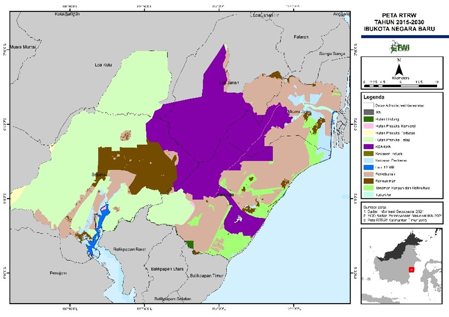
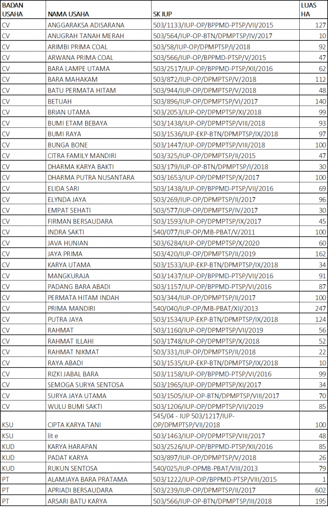
Watershed in IKN region are listed below:

West : Mahakam, Sei Sepaku, Pemaluan, Sungai Trunen, Sungai Semuntai, Telake, Riko

Central : Semoiseluang, Tempadung River, Sijaung River, Kemantis River, Bear River, Beranga River

East : Gelondrong River, Senipah River, Palas River, Samboja Kuala, Selokapi, Samboja, Mangga Besar, Teritip

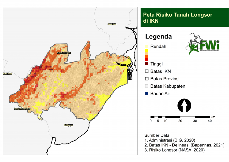
Proper watershed management in IKN crucial to support the availability of clean water and prevent disasters such as floods and landslides. Forest cover in each watershed must be maintained at least 30% of the area and the degraded area should be returned to its original function. Hilly areas and watersheds that have also been burdened with permits have the tendency to undermine soil and water conservation principles.

Capital relocation is a megaproject with major impacts on the safety of living things, including Indigenous Peoples. AMAN noted that there are 21 indigenous communities in the area of ​​the IKN development plan. There are 19 indigenous communities in North Penajam Paser and 2 in Kutai Kartanegara. Eleven indigenous communities were identified in the core zone of IKN development. These findings emphasized that Nusantara development area was not built on an empty land.

In 2018 FWI conducted a study on analysis the existence of customary territories in Indonesia by analysing relevant factors, such customary territory map from Customary Territory Registration Agency (Badan Registrasi Wilayah Adat , BRWA), distribution of tribes, regional languages, ​​and topography. The study indicated that there are 69% of the land which is indicated as customary territory in Kalimantan[3]. In 2022, FWI planned to issue the analysis related to the existence of these customary territories in the IKN, which occupies 55% of IKN area (Figure 8.).

Transparency is more important now than ever, due to the nature and scale of issue complexity and affected parties in the capital relocation to Nusantara. With transparency, indigenous peoples and communities will have the opportunity, access, and options regarding the proposed policies, and that public participation is no longer undermined. For Transparency to work as intended, all parties must have relevant information that are shared between policy makers and indigenous peoples (public) to break the asymmetric chain of information and make policies that safeguard all aspects.

Referensi:
[1] Sumber https: //kaltimkece.id/historia/peristiwa/mengenang-kejayaan-pt-itci-perusahaan-mati-suri-yang-lokasinya-menjadi-ibu-kota-negara
[2] https://tirto.id/jejak-bisnis-angkatan-darat-dan-adik-prabowo-di-penajam-paser-utara-ehe7
[3] Indikatif Wilayah Adat, FWI 2018

Asimetris Informasi: Apa Yang Tidak Muncul Ke Publik Dari Pemindahan IKN?


Thank you for your vote!
Post rating: 0 from 5 (according 0 votes)

Add Comment

Get the latest news via email

Good Forest Governance Needs Good Forest Information.


Using and sharing site content | RSS / Web Feeds

Photos and graphics © FWI or used with permission. Text available under a Creative Commons licence.

© Copyright 2020 FWI.
All Rights Reserved.

to top